Topographic maps symbols. Topographic symbols and designations of forests, shrubs, gardens, etc. Explanation of a new topic
"Mysterious" signs and symbols on old maps. As roads were designated, houses, churches, ravines, cemeteries, etc.


Deciphering some abbreviations and words on the MENDE map:
Buyan-field - A flat, elevated place, open from all sides
Vzlobok - A small steep hill.
Veres - Juniper.
Volok (Drag) - Forest or forest clearing
Vspole - Edge of the field, pasture.
Vyselok (Vys.) - A small village, mostly owner-occupied, located near single-patrimonial villages.
Vyaschshiy - The largest, highest, high.
City (G.) - A fortified or walled village. Management status assigned to a volost, county or provincial in relation to other settlements.
Mane - An oblong hill covered with forest.
Village - A village without a church, whose inhabitants are predominantly peasants of various departments and live without a landowner.
Hand - Right hand.
Dresva - Coarse sand.
Zapan - Backwater or river bay.
Zasek (Zas.) - Defensive structure. It was a combination of forest dead fences, an earthen rampart and a moat with prisons and separate fortresses. The fortifications served as defensive lines, protecting against the raids of the Golden Horde, who systematically robbed and destroyed Russian cities and villages and drove the population into captivity, as well as to protect roads.
Zybun (Zyb.) - A bog, an impassable (dead) place.
Koshevnik - Firewood rafted down the river.
Cumulus sands (Kuch.) - Accumulations of loose sand around bushes and shrubs ... Height 30-50 cm, less often up to 1-2 m. In some places they consist of gravel. They usually form in areas with close groundwater - on salt marshes, on the coasts of lakes, seas and rivers.
Lyady meadow - Worthless, bad meadow.
Monastery, monastery (Mon.) - They make up various types of monastic hostels, of which the latter sometimes coincide in their meaning with graveyards or estates of a spiritual department.
Myza (m. or Myza) - If it is owner-occupied, then for the most part it is near one-patrimonial villages, or it has the meaning of a manor at a plant and a factory, if it belongs to persons of taxable estates.
Myanda - Pine.
Novina - Cleared, but not plowed land in the forest.
Dump (Rev.) - An embankment of waste rocks, slag, formed during the development of minerals.
Touchstone - Touchstone Vlad. wasteland, a place abandoned by the inhabitants; fallow, deposit. Obselok, Oblesye, Obselok or obselye, psk. hard. newly populated place, settlement, new settlements, settlements.
Oselye - Oselye is akin to the outskirts, the land around the village.
Perekop - Ditch.
Chaff - Weed
Pogost (Pogost or Pogost) - Has a church and a population consisting of clergy and clergy. The word churchyard comes from the word guest. The place where the merchants traded was called the churchyard. With the adoption of Christianity, churches began to be erected at churchyards. In 15-16 centuries. graveyards begin to die off, hence the word graveyard has a second meaning - a lonely standing church.
Podsek (Pod.) - A cleared place in the forest.
Disgrace - Review, look.
Midnight - North.
Posad (P. or Pos.) - The order of the huts or a number of houses. A settled settlement located outside a city or fortress.
Pochinok, village and farm (Poch.) - The same as a settlement. Farms, however, often have the meaning of estates due to their agricultural character. New settlements that appeared on the first uplifted site were called pochinkas. When one or two others appeared with the original courtyard in repair, it became a village.
Wasteland (Empty) - The village turned into a wasteland if there were no residential yards left in it and arable land was abandoned.
Settlement - A large village or settlement where there is more than one church.
Village (S.) - A village with a church, which has residents mainly from peasants of different departments.
Seltso (Sel.) - A village of an exclusively proprietary nature with a master's house and various owner-occupied institutions, or a village in which a landowner lives with peasants or several landowners. It may also have the name of a village that was formerly a village.
Sloboda, Forshtat (Slob.) - A village with more than one church, a settlement outside a city or fortress.
Terniye - Thorny bush
Manor (Us.) - They are of two kinds. The manors of the spiritual department are similar to churchyards in terms of the nature of the population. Owner's estates differ either in their agricultural character or as the location of landowners at a factory or factory
Shuytsa - Left hand.
Church land (CL) - Land allotment belonging to a church parish or monastery.
Information from the Lithuanian forum http://forum.violity.com Thank you, comrades!
Designations from old maps:
Interpretation of the signs used in the atlas of the Russian Empire in 1745:

Explanation of the signs used in the atlas of the Russian Empire 1820-27.

Explanations of signs used in the 1910 atlas

Symbols used on the Special Map of the Western Part Russian Empire(Schubert map).
Symbols used in the Detailed Military Map along the Russian-Prussian Border, 1799

P.S. Found treasures
Our trimaran loaded with heavy diving equipment, half a ton of cargo, goes south to the village of Khatgal, Mongolia, where the old ships found their last refuge.
During the week we found and examined four ships in Lake Khuvsgul.
Every card has its own special language- special symbols. Geography studies all these designations, classifies them, and also develops new symbols to designate certain objects, phenomena and processes. It is useful for absolutely everyone to have a general idea of conventional cartographic signs. Such knowledge is not only interesting in itself, but will certainly be useful to you in real life.
This article is devoted to conventional signs in geography, which are used in the preparation of topographic, contour, thematic maps and large-scale plans terrain.
ABC cards
Just as our speech consists of letters, words and sentences, so any map includes a set of certain designations. With their help, topographers transfer this or that area onto paper. Conventional signs in geography are a system of special graphic symbols used to designate specific objects, their properties and characteristics. This is a kind of "language" of the map, created artificially.
It is rather difficult to say exactly when the very first geographical maps appeared. On all continents of the planet, archaeologists find ancient primitive drawings on stones, bones or wood, created by primitive people. So they depicted the area in which they had to live, hunt and defend themselves from enemies.
Modern conventional signs on geography maps display all the most important elements terrain: landforms, rivers and lakes, fields and forests, settlements, communication routes, country borders, etc. The larger the image scale, the more objects can be mapped. For example, on a detailed plan of the area, as a rule, all wells and sources of drinking water are marked. At the same time, marking such objects on a map of a region or country would be stupid and impractical.
A bit of history or how the symbols of geographical maps have changed
Geography is a science that is unusually closely related to history. Let's delve into it and we will find out how cartographic images looked many centuries ago.
Thus, the ancient medieval maps were characterized by the artistic rendering of the area with the widespread use of drawings as conventional signs. Geography at that time was just beginning to develop as a scientific discipline, therefore, when compiling cartographic images, the scale and outlines (boundaries) of area objects were often distorted.

On the other hand, all the drawings on the old drawings and portolans were individual and completely understandable. But nowadays you have to connect your memory in order to learn what these or other conventional signs on maps in geography mean.
From about the second half of the 18th century, there was a tendency in European cartography to gradually move from individual perspective drawings to more specific plan symbols. In parallel, there was a need for a more accurate display of distances and areas on geographical maps Oh.
Geography: and topographic maps
Topographic maps and terrain plans are distinguished by rather large scales (from 1:100,000 or more). These are the ones most often used in industry, agriculture, exploration, urban planning and tourism. Accordingly, the terrain on such maps should be displayed as detailed and detailed as possible.
For this, a special system of graphic symbols was developed. In geography, it is also often called the "map legend". For ease of reading and ease of remembering, many of these characters resemble the real thing. appearance the objects of the terrain depicted by them (from above or from the side). This system of cartographic symbols is standardized and mandatory for all enterprises that produce large-scale topographic maps.
The topic "Conventional signs" is studied in the school geography course in the 6th grade. To test the level of mastery of a given topic, students are often asked to write a short topographical story. Each of you probably wrote a similar “essay” at school. Offers with conventional signs for geography look something like the photo below:

All symbols in cartography are usually divided into four groups:
- large-scale (areal or contour);
- off-scale;
- linear;
- explanatory.
Let us consider in more detail each of these groups of signs.
Scale signs and their examples
In cartography, scale signs are those that are used to fill in any areal objects. It can be a field, a forest or an orchard. With the help of these conventional signs on the map, you can determine not only the type and location of a particular object, but also its actual size.
The boundaries of areal objects on topographic maps and terrain plans can be depicted as solid lines (black, blue, brown or pink), dotted or simple dotted lines. Examples of scale cartographic signs are shown below in the figure:

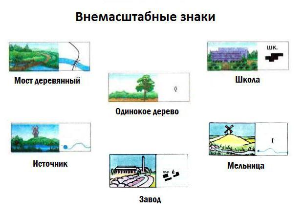
off-scale signs
If the object of the area cannot be depicted in the real scale of the plan or map, then in this case off-scale symbols are used. We are talking about too small, maybe, for example, a windmill, a sculptural monument, a rock-outlier, a spring or a well.
The exact location of such an object on the ground is determined by the main point of the symbol. For symmetrical signs, this point is located in the center of the figure, for signs with a wide base - in the middle of the base, and for signs that are based on a right angle - at the top of such an angle.
It is worth noting that the objects expressed on the maps by non-scale conventional signs serve as excellent landmarks on the ground. Examples of off-scale cartographic signs are shown in the figure below:
Linear signs
Sometimes the so-called linear cartographic signs. It is easy to guess that with their help linearly extended objects are designated on plans and maps - roads, boundaries of administrative units, railways, fords, etc. Interesting feature linear symbols: their length always corresponds to the scale of the map, but the width is significantly exaggerated.
Examples of linear cartographic symbols are shown in the figure below.

Explanatory signs
Perhaps the most informative is the group of explanatory conventional signs. With their help, additional characteristics of the depicted terrain objects are indicated. For example, a blue arrow in a riverbed indicates the direction of its flow, and the number of transverse strokes on the designation railway corresponds to the number of paths.
On maps and plans, as a rule, the names of cities, towns, villages, mountain peaks, rivers and others are signed. geographical objects. Explanatory symbols can be numeric or alphabetic. Letter designations are most often given in an abbreviated form (for example, a ferry crossing is indicated as an abbreviation "par.").
Symbols for contour and thematic maps
A contour map is a special kind of geographical maps intended for educational purposes. It contains only a coordinate grid and some elements of the geographical basis.
The set of conventional symbols for contour maps in geography is not very wide. The very name of these maps is quite eloquent: for their compilation, only contour designations of the boundaries of certain objects - countries, regions and regions - are used. Sometimes rivers are also applied to them and big cities(in the form of dots). By and large, contour map- this is a "silent" map, which is just designed to fill its surface with certain conventional signs.
Thematic maps are most often found in atlases of geography. The symbols of such cards are extremely diverse. They can be depicted as a color background, areas or so-called isolines. Diagrams and cartograms are often used. In general, each type of thematic map has its own set of specific symbols.
Topographic (cartographic) symbols - symbolic dashed and background symbols of terrain objects used to depict them on topographic maps .
For topographic conventional signs, a common designation (in style and color) of homogeneous groups of objects is provided, while the main signs for topographic maps different countries do not differ significantly from each other. As a rule, topographic symbols convey the shape and size, location, and some qualitative and quantitative characteristics of objects, contours, and relief elements reproduced on maps.
Topographic symbols are usually divided into large-scale(or areal), off-scale, linear and explanatory.
scale, or areal conventional signs serve to depict such topographic objects that occupy a significant area and whose dimensions in terms of plan can be expressed in scale given map or plan. An areal symbol consists of a boundary symbol of an object and symbols that fill it or a symbolic coloring. The outline of an object is shown as a dotted line (outline of a forest, meadow, swamp), a solid line (outline of a reservoir, settlement) or a symbol of the corresponding boundary (ditch, fence). Filling characters are located inside the contour in a certain order (arbitrarily, in a checkerboard pattern, in horizontal and vertical rows). Areal symbols allow not only to find the location of an object, but also to evaluate its linear dimensions, area and outlines.
Out-of-scale conventional symbols are used to convey objects that are not expressed on the scale of the map. These signs do not allow us to judge the size of the depicted local objects. The position of the object on the ground corresponds to a certain point of the sign. For example, for a sign of the correct form (for example, a triangle denoting a point of a geodetic network, a circle - a cistern, a well) - the center of the figure; for a sign in the form of a perspective drawing of an object (factory chimney, monument) - the middle of the base of the figure; for a sign with a right angle at the base (wind turbine, gas station) - the top of this angle; for a sign that combines several figures (radio tower, oil rig), the center of the lower one. It should be noted that the same local items on maps or plans of large scales they can be expressed by areal (scale) symbols, and on maps of small scales - by off-scale symbols signs.
Linear conventional signs are designed to depict extended objects on the ground, such as railways and roads, clearings, power lines, streams, borders, and others. They occupy an intermediate position between large-scale and off-scale conventional signs. The length of such features is expressed at the scale of the map, while the width on the map is not to scale. Usually it turns out to be greater than the width of the depicted terrain object, and its position corresponds to the longitudinal axis of the symbol. Linear topographic symbols also depict horizontal lines.
Explanatory symbols are used to additionally characterize the local objects shown on the map. For example, the length, width and carrying capacity of the bridge, the width and nature of the road surface, the average thickness and height of trees in the forest, the depth and nature of the ford soil, etc. Various inscriptions and proper names of objects on the maps are also explanatory; each of them is performed in a set font and letters of a certain size.
On topographic maps, as their scale decreases, homogeneous conventional signs are combined into groups, the latter into one generalized sign, etc., in general, the system of these designations can be represented as a truncated pyramid, which is based on signs for topographic scale plans 1: 500, and at the top - for survey topographic maps at a scale of 1: 1,000,000.
The colors of topographic symbols are the same for maps of all scales. Line marks of lands and their contours, buildings, structures, local objects, strongholds and boundaries are printed in black when published; relief elements - brown; reservoirs, streams, swamps and glaciers - blue (water mirror - light blue); areas of tree and shrub vegetation - green (dwarf forests, elfins, shrubs, vineyards - light green); neighborhoods with fire-resistant buildings and highways - orange; neighborhoods with non-fireproof buildings and improved dirt roads in yellow.
Along with conventional signs for topographic maps, conditional abbreviations of their own names of political and administrative units (for example, Moscow region - Mosk.) and explanatory terms (for example, power plant - el.-st., swamp - bol., southwestern - SW) . Standardized fonts for inscriptions on topographic maps allow, in addition to conventional signs, to give essential information. For example, fonts for the names of settlements display their type, political and administrative significance and population, for rivers - the size and the possibility of navigation; fonts for height marks, characteristics of passes and wells make it possible to highlight the main ones, etc.
The terrain on topographic plans and maps is depicted by the following methods: methods of strokes, hillshade, color plastics, marks and contour lines. On large-scale maps and plans, the relief is depicted, as a rule, by the contour lines method, which has significant advantages over all other methods.
All conventional signs of maps and plans should be clear, expressive and easy to draw. Conventional signs for all scales of maps and plans are established by regulatory and instructive documents and are mandatory for all organizations and departments performing survey work.
Taking into account the variety of agricultural lands and objects, which does not fit into the framework of mandatory symbols, land management organizations issue additional symbols reflecting the specifics of agricultural production.
Depending on the scale of the maps or plan, local items are shown in varying detail. So, for example, if on a plan of scale 1: 2000 in a settlement not only individual houses, but also their shape are shown, then on a map of scale 1: 50,000 - only quarters, and on a map of scale 1: 1,000,000 the whole city will be indicated small circle. Such a generalization of the elements of the situation and relief in the transition from larger scales to smaller scales is called map generalization .


Topographic signs and symbols of bushes and shrubs
How are the elements of land cover, gardens, plantations, etc., designated?
Let's start with swamps. According to the degree of patency, they are divided into
Passable: swamps through which infantry can move in any direction in summer, both in open and closed formations.
Difficult: swamps through which infantry can move with considerable difficulty and only in open formations.
Impassable: not even one person can pass
Conventional explanatory signs of age and forest species
.jpg)
Conventional signs and cartographic designations of swamps
.jpg)
Conventional signs and cartographic designations of sands and steppes
.jpg)
Conventional signs and cartographic designations of lands, plantations, etc.

.jpg)
Sometimes you may come across a combination of symbols. For example, a wet meadow and swamps where hay is produced are marked with swamp and meadow signs.
To correctly use a topographic map, you need to familiarize yourself with the generally accepted symbols and designations. When drawing up topographic maps and plans, various objects located on the displayed area are indicated by special conventional signs.
The main objects on the map include the following items:
- Cities.
- Settlements.
- Rivers, ponds and other bodies of water.
- The mountains.
- Industrial enterprises.
The presented list does not include all the objects placed on the maps.
Varieties of symbols
Conventional signs of topographic maps are large-scale (contour), off-scale, linear, explanatory.
Scale symbols of topographic maps are used to depict terrain objects, which are expressed in the appropriate scale. The area of such objects can be measured directly on the map using a ruler with divisions.
For example, in order to approximately know the size of a lake, forest, settlement, you need to calculate the area of \u200b\u200bthe object on the map (draw it into cells of 1 cm2, count the number of full and incomplete cells), and then, using the scale, translate the result into kilometers.
With the help of off-scale symbols, specific objects located on the ground are shown, which are not depicted on the map scale. For example, if it is necessary to put on a map, a stand-alone pole, tree, building, geodetic point, etc. They are deliberately depicted in an enlarged form.
To indicate the exact position of a given object on the map, the main point is placed in the center of a symbol - a square, a circle, an asterisk, etc.

Linear conventional signs depict horizontal lines and extended objects on the ground. These include the following designations:
- railways;
- highways;
- electrical lines;
- glades;
- rivers, streams;
- border markings.
The length of such objects is expressed in accordance with the scale of the map. The width of these symbols is displayed regardless of the scale. It usually exceeds the actual size. The longitudinal axis of the conventional sign is applied to the terrain plan in accordance with the location of the object (parallel).
To give an additional description of one or more objects on the ground, explanatory conditionals are used. topographical signs, symbols and captions.
For example:
- the outlines of a deciduous or coniferous tree in the forest area indicate the prevailing species of plantations, the average height and thickness of their trunks;
- with the help of transverse strokes on the conditional icon of the railway track, the number of tracks is indicated;
- letters and numbers on the highway - road surface material, track width;
- designation of the dimensions of the bridges, as well as their carrying capacity.
Explanatory symbols on topographic maps and plans provide more complete information about the nature of the area.
Proper names, explanatory inscriptions, etc. are applied to the topographic map in a special font, the letters have a certain size.

Permissible conventions on the map
Sometimes a topographic map contains an image of individual objects in conventional form. For example, the outer boundaries of a particular locality. In this case, the main highways and intersections are indicated. If some buildings are depicted, they characterize the building density, but not their exact number.
In order to show the dense arrangement of homogeneous objects (houses, mounds, wells, etc.), only objects that stand on the boundaries of a given area are depicted, in accordance with their exact location.
Conditional symbols of industrial enterprises (factories, factories) are placed in places where the main building or the highest factory chimney is located.
Symbol sizes
To the left of the conventional symbol are numbers that display its dimensions in millimeters on the map. The two captions indicate the height and width of the rectangular character. If the inscription is one, this indicates that both values are equal to each other.
The familiar conventional icon - a circle has a digital signature indicating its diameter. The star is the diameter of the circumscribed circle, the equilateral triangle is its height.
Symbol colors
Regardless of the scale of the map, various topographic symbols are painted in certain colors and shades:
- The contours of the borders, dashed signs of land plots are black.
- Relief elements - brown background shading.
- Rivers, glaciers, swamps - blue lines, hatching.
- Water mirror - blue background.
- Areas with trees, shrubs - green.
- Vineyards - light green.
- Fire-resistant buildings, asphalt roads - orange.
- Non-fireproof buildings, dirt roads - yellow.

In addition to conventional symbols, topographic maps put their own names in abbreviated form of various regions, districts, and other significant objects (Moscow, el.-st., SW, Bol. - swamp). Topographic maps provide additional information using standard fonts.
For example, the depth, the course of the river, as well as the possibility of navigation along it. Heights of hills, depths of wells, the number of people in towns and cities are marked with special fonts.


